
Hiking in the Dolomites: 8 hikes and walks to add to your itinerary
Visiting the Dolomites is a dream of many travelers from around the world. Gorgeous blue lakes and scenic mountain backdrops invite you to forget the hustle and bustle of daily life and immerse yourself in vast alpine landscapes.
One of the best ways to explore the Doloimtes’ natural beauty is hiking. There are countless trails to choose from in each of the nine sub-regions. You’ll find easy and flat walks suitable for families and complete beginners, as well as longer and more challenging options for the experienced hiker.
We’ll look at eight amazing hikes in the Dolomites that you can choose from based on your fitness and experience. They are divided into four difficulty levels: easy & flat, moderate, moderately strenuous, and full-day hiking challenge. Read on to find out what these categories entail.
READ MORE | Training for hiking: 7 ways to get in shape for your next hike

There’s no shortage of stunning vistas

The trails are well marked
Level 1: Easy & flat
This level includes relaxed hikes of no more than five kilometres with barely any elevation gain/loss. They are suitable for total newbies, casual strollers, and families with children.
Lago di Braies loop
📏 Distance: around 3.5 kilometres
⏱ Time needed: at least an hour to enjoy the scenery
⛰ Elevation gain/loss: around 40 metres
🚶♀️ Trail type: circular
📍 Starting point: one of the Lago di Braies parking lots (P4 is the closest to the lake)
The Dolomites’ famous icon, Lago di Braies, absolutely lives up to its hype. It’s a gorgeous blue lake with stunning scenery as far as the eye can see and an easy walking path that’ll take you along the lake’s shore.
The loop is ideal for families with small children, non-hikers, or as a rest day activity. You could complete it in less than an hour if you wanted to, but I wouldn’t recommend it. After all, the goal of this hike is not a physical challenge but to take things slow and take in the beautiful scenery this place offers.

Make sure you see the lake from all sides

Lago di Braies is especially magical in the morning
To enjoy a crowd-free experience, arrive very early or very late in the day and ideally outside the main season of July and August. As much as a summer sunrise gives you a moment without swarms of tourists, this place is no hidden gem, so it’s unlikely that you’ll have the lake all to yourself.
However, even with crowds, Lago di Braies is nothing short of magical. To enjoy it from a different perspective, rent one of the row boats.
Loop around Lago di Dobbiaco
📏 Distance: 2.5-4.5 kilometres
⏱ Time needed: at least 30 minutes
⛰ Elevation difference: 10 metres
🚶♀️ Trail type: circular
📍 Starting point: Camping Toblacher See
Overlooked by many tourists in favour of the more famous and “Insta-worthy” lakes, Lago di Dobbiaco offers a great off-the-beaten-path adventure. The main nature trail around the lake is accessible to pushchairs, making this loop an option for literally anyone.
Walk counter-clockwise and observe the diverse flora and fauna. This hike is best enjoyed in combination with a picnic at the lake shore and dipping in the ice-cold water or stand-up paddleboarding. Dedicate at least an afternoon to the experience.

Lago di Dobbiaco after sunset
Level 2: Moderate
These hikes are up to 10 kilometres long and typically require three to four hours to complete. The elevation gain/loss is no more than 500 metres, making them a nice challenge for those who don’t feel super fit just yet or those who just don’t really enjoy long hikes. They’re a relaxed option for active hiking enthusiasts.
Santa Maddalena Panorama Trail
📏 Distance: six to nine kilometres depending on the trail you choose
⏱ Time needed: 3:30 hours
⛰ Elevation gain/loss: 380 metres
🚶♀️ Trail type: circular or out and back depending on the trail you choose
📍 Starting point: Santa Maddalena village
🗺 Hiking route: Santa Maddalena village — Church of St. Maddalena — Panoramaweg — Vikoler Jöchl — Sunnseitnweg — Santa Maddalena village
The Santa Maddalena Panorama Trail is a wonderful option to experience Val di Funes. It takes no more than an afternoon and in that time, you’ll see everything that makes this region so iconic: mountain valleys, old churches, and pretty villages.
From the village of Santa Maddalena, head up to the church on the hill and admire its 14th-century tower. Then follow Magdalenaweg and Panoramaweg trail signs.

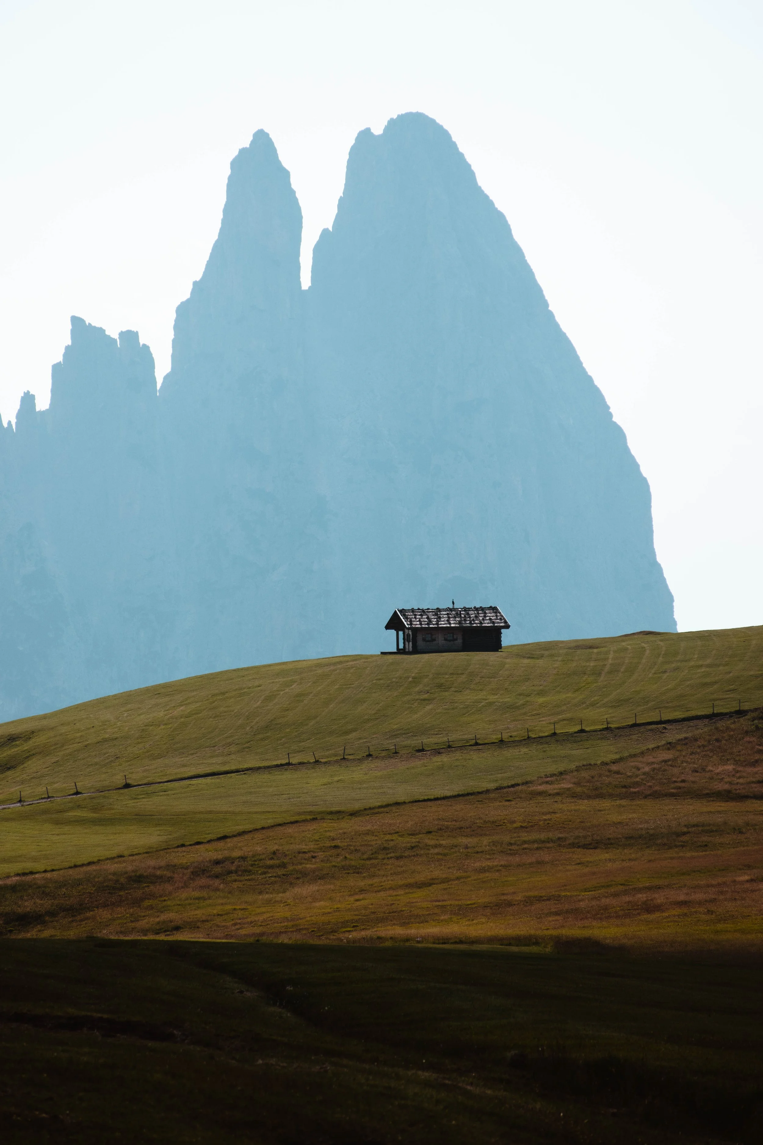
A classic postcard view — St. Maddalena church with Geisler/Odle peaks in the background

Can you spot the Church of St. John in Ranui in the distance?
As you walk the trail, remember to look back every now and then. The iconic Geisler/Odle peaks create a fascinating backdrop for the village and the local churches.
You can continue up to Vikoler Jöchl and then head back to Santa Maddalena via Sunnseitnweg to taste some local dumplings for dinner.
Adolf Munkel Trail
📏 Distance: nine kilometres
⏱ Time needed: three to four hours
⛰ Elevation gain/loss: 370 metres
🚶♀️ Trail type: circular
📍 Starting point: Zannes car park
🗺 Hiking route: Zanseralm — Duslerhütte — Geisler Alm — Gschnagenhardt Alm — Zanseralm via trail 35 (Adolf Munkel Weg) and 36
With its relatively short distance and small elevation gain/loss, the Adolf Munkel Trail is great for novice hikers and families. You’ll be taken through various alpine landscapes without much physical exertion.
For the best views, it’s best to do this hike counterclockwise. Start at Zanseralm and make your way through the forest towards Duslerhütte and then to Geisler Alm — a perfect place to take a break, admire views of the Odler/Geisler peaks, and taste delicious Kaiserschmarrn.

In the heart of Dolomites

Beautiful scenery on every corner
When you’re ready, continue across the alpine pasture towards Gschnagenhardt Alm and connect onto the actual Adolf Munkel Weg (trail 35). Crossing what literally feels like the heart of the Alps, this is the most picturesque part of the trail.
From Adolf Mungel Weg, connect onto trail 36 to return to the parking lot.
Tre Cime di Lavaredo circuit trail
📏 Distance: 9.5 kilometres
⏱ Time needed: four hours
⛰ Elevation difference: 430 metres
🚶♀️ Trail type: circular
📍 Starting point: Rifugio Auronzo
🗺 Hiking route: Rifugio Auronzo — Rifugio Lavaredo — Forcella Lavaredo — Drei-Zinnen-Hütte — Langalm — Rifugio Auronzo
Located in the Eastern part of the Dolomites, the Tre Cime di Lavaredo (Drei Zinnen) circuit trail offers a blend of stunning vistas, alpine valleys, and iconic mountain peaks.
Drive up to Rifugio Auronzo via a toll road. The parking spots up on the mountain are limited, so it’s best to do this early in the day to avoid waiting in a queue. The three iconic peaks will be the first thing to catch your attention once you get up.
Start walking around the Drei Zinnen counterclockwise and look for interesting viewpoints to your right. From the Drei-Zinnen-Hütte, descend into an alpine valley full of cute cows and hike back up to Langalm, a nice place to enjoy homemade soup and pie.
To top off this hiking adventure, consider stopping by Lago di Misurina on your way home. It’s one of the most beautiful lakes in the Dolomites.

The Drei Zinnen (Tre Cime di Lavaredo) have a very distinctive shape
Level 3: Moderately strenuous
Level three features 10 to 15 kilometres-long hikes with an elevation gain/loss between 500 and 1000 metres. The trails may have a few tricky sections and offer a good physical challenge without having to cover too much distance.
Seceda mountain top to Rifugio Firenze
📏 Distance: nine kilometres
⏱ Time needed: 3:30-4 hours
⛰ Elevation difference: 525 metres
🚶♀️ Trail type: circular
📍 Starting point: Seceda Mountain Station
🗺 Hiking route: Seceda Mountain Station — Pieralongia — Rifugio Firenze — Lech da Iman — Baita Troier — Seceda Mountain Station
With its jagged peaks looming above the villages of Ortisei, St. Christina, and Selva, Seceda ridgeline pierces the sky at an altitude of 2500 metres. The mountain top, reachable by cable car from Ortisei, is the starting point for many hiking adventures in the area.
One such adventure is the circuit hike via Rifugio Firenze, which can be comfortably completed in about half a day. Starting from the Seceda Mountain Station and Panorama Point, make your way via trails 1 and 2B past Pieralongia, eventually turning right to follow trails 13B and 13 towards Rifugio Firenze (Regensburger Hütte).

The iconic Seceda ridgeline

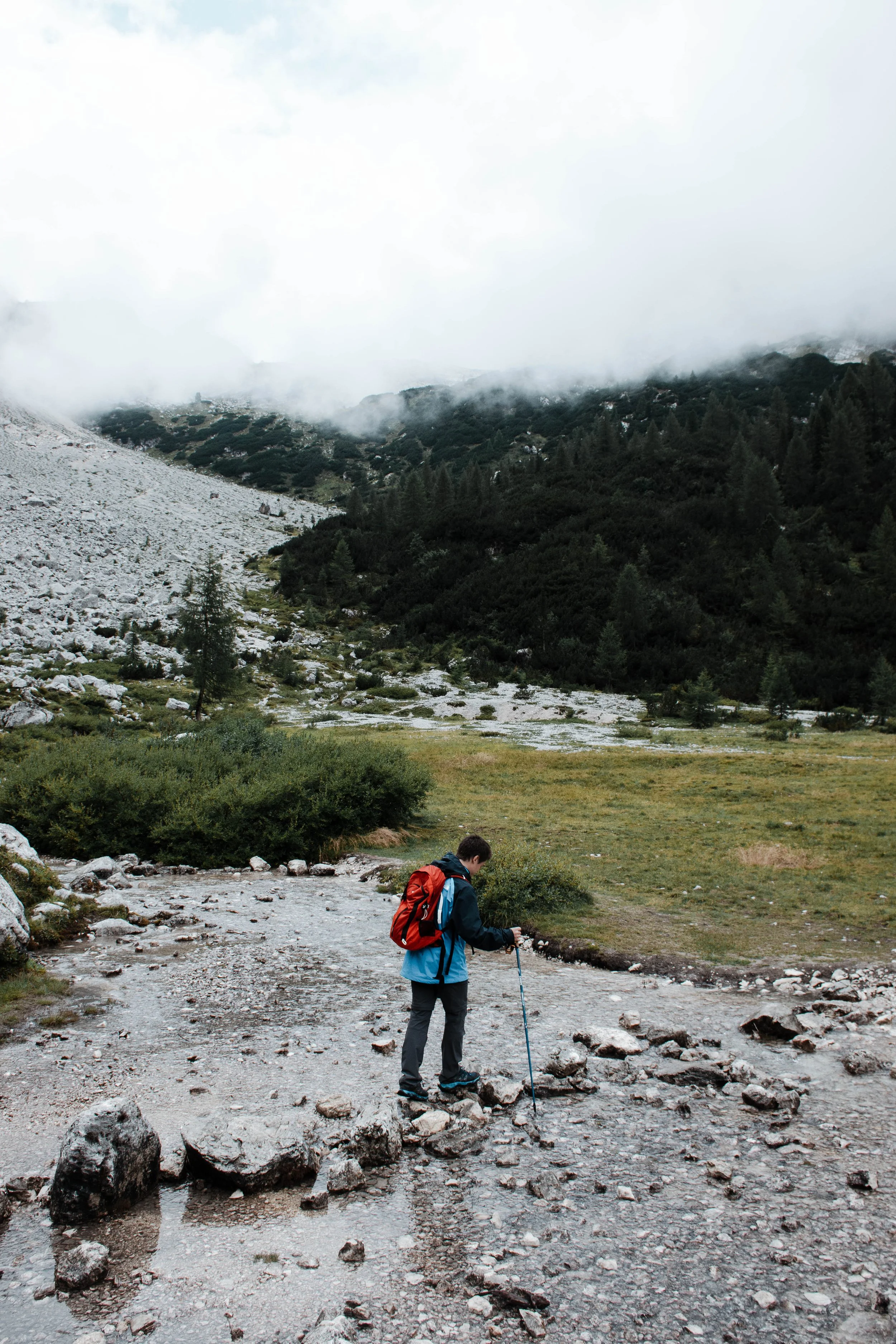
Hiking poles can be a great tool on this hike
The winding trail will have you descend through the valley around some impressive rock formations. If you wish — and the trail is open — you can add a little detour via Furcella de Pana.
Enjoy a refreshment at Rifugio Firenze before you begin the ascent back to the Seceda Mountain Station via trail 1, passing Lech da Iman and Baita Troier.
The hike isn’t technically difficult but the steepness of the ascent can take you by surprise. If you’re not sure whether your body is physically up for that challenge but still want to go for it, set aside an extra hour or two for the hike.
Hike to Lago di Sorapis
📏 Distance: 11 kilometres return
⏱ Time needed: four to six hours
⛰ Elevation gain/loss: 725 metres
🚶♀️ Trail type: out and back
📍 Starting point: Passo Tre Croci
The milky blue Lago di Sorapis perched under the impressive Dito di Dio peak is undoubtedly one of the most breathtaking places in the Dolomites. The hike to the lake is moderately strenuous but your efforts will be rewarded accordingly.
The route up to the lake is pretty straightforward. Follow trail 215 which you can also take to return. It takes about two to three hours to reach the lake. Narrow, half-exposed passages secured with cables are to be expected but not to be feared in decent weather with proper hiking shoes and a bit of caution.
I can guarantee that the moment you first lay your eyes on Lago di Sorapis will be one of the most memorable of your trip through the Dolomites. The small alpine pastures on the further side of the lake are a wonderful place to relax, tucked away from the rest of the world.

Milky blue water of the lake and Dito di Dio shrouded in clouds
Take the time to walk around the lake and explore its further side
The hike is increasingly popular so as always, it pays off to be one of the first hikers to arrive at Passo Tre Croci and hit the trail — especially in peak tourist season. Lago di Sorapis tends to dry up towards the end of summer, so plan your visit accordingly.
Level 4: Full-day hiking challenge
Hikes in this category are longer than 20 kilometres. You should dedicate a full day to completing them and expect an elevation gain/loss of 1000 metres and more. They may not necessarily pose technical difficulties. However, they do require stamina and a good fitness level to complete. Hiking poles are recommended for hikes in this category.
Alpe di Siusi — Alpe di Tires circuit hike via Sciliar Plateau
📏 Distance: around 25 kilometres
⏱ Time needed: 8+ hours
⛰ Elevation gain/loss: 1100+ metres
🚶♀️ Trail type: circular
📍 Starting point: Compatsch
🗺 Hiking route: Compatsch — Saltner Hütte via Alpe di Siusi — Rifugio Bolzano — Rifugio Alpe di Tires — Forcella Denti di Terrarossa — Compatsch via Alpe di Siusi
Europe’s largest high-altitude Alpine meadow, Alpe di Siusi, is as high on the Dolomites' bucket list as some of the region’s most stunning lakes.
While you can easily pay a quick visit, snap a few photos, and return home, it is much more fun to immerse yourself in the vast landscape by completing a challenging day hike.

Standing on Europe’s largest high-altitude Alpine meadow is quite the experience
The Alpe di Siusi — Alpe di Tires circuit starts at the parking lot in Compatsch. The road to Compatsch is closed to private vehicles between 9 AM and 5 PM, so an early start is a must. Alternatively, you can use the Alpe di Siusi Aerial Cableway from Siusi allo Sciliar (Seis am Schlern).
The steep ascents and descents, and its impressive length are what make this hike a challenging one. Start by traversing Alpe di Siusi towards Saltner Hütte. This will take about an hour. The modest mountain hut is a good place to stop for a cup of espresso and a quick snack. Why? From here, you’ll begin the first long and tiring ascent to Rifugio Bolzano on the Sciliar Plateau.

From Saltner Hütte, you can see the ascent to Rifugio Bolzano. Enjoy the view while you’re drinking coffee because once you’re on the trail, things will get tough.
Once you’re up, catch your breath and slowly continue across the Sciliar Altiplano. It’ll take about an hour before you catch the first glimpse of Rifugio Alpe di Tires in the distance.
From that moment, you still have a long way to go. The descending trail is narrow and at times exposed, but in good condition. If you have hiking poles, I’d strongly advise you to take them for support.
Have a quick drink and refill your water bottle at Rifugio Alpe di Tires, and continue onwards to Forcella Denti di Terrarossa, down to Alpe di Siussi, and back to Compatsch, where you’ll complete this quest.

Alpe di Tires in the distance. That narrow winding path you see is where you’ll be walking.
Back at Alpe di Siusi
———
Hiking in the Dolomites is an experience that should definitely be part of your travel wishlist. The region brims with natural wonders and there is something unique to discover on every hike, whether you’re a novice or a pro.


Which of these hikes will you be adding to your Dolomites itinerary? Let me know in the comments!