
Road trip through the Alps: 5 days in Austria and Switzerland
This post contains affiliate links. If you make a purchase through one of my links, I may earn a small commission at no additional cost to you. This allows me to keep creating content about the outdoors & travel. Thank you for your support!
One of the great things about Europe is that everything is relatively close. Within just a few hours, you could cross borders of three — if not four or five — different countries.
If you’re looking for a quick outdoorsy getaway, Austria and Switzerland are THE places for that. What the two countries have in common is not just the language and breathtaking scenery, but also countless hiking trails and overall great infrastructure for road trippers.
This itinerary combines some of the most iconic Swiss and Austrian lakes, hikes ranging from easy breezy to long and challenging, Europe’s largest waterfall, as well as some downtime to take it all in.
It will best serve two types of travellers. Firstly, is the traveller who’s coming to Europe from overseas and is keen to see the best of multiple countries within a relatively short time.
Secondly, a traveller from Europe who wants a ready-made itinerary for a quick trip through two of the most beautiful countries this continent has, or just needs some inspiration to create his own adventures in the Alps.
We’ll go step-by-step through all the activities you can do each day to make the most out of both countries without having to rush.
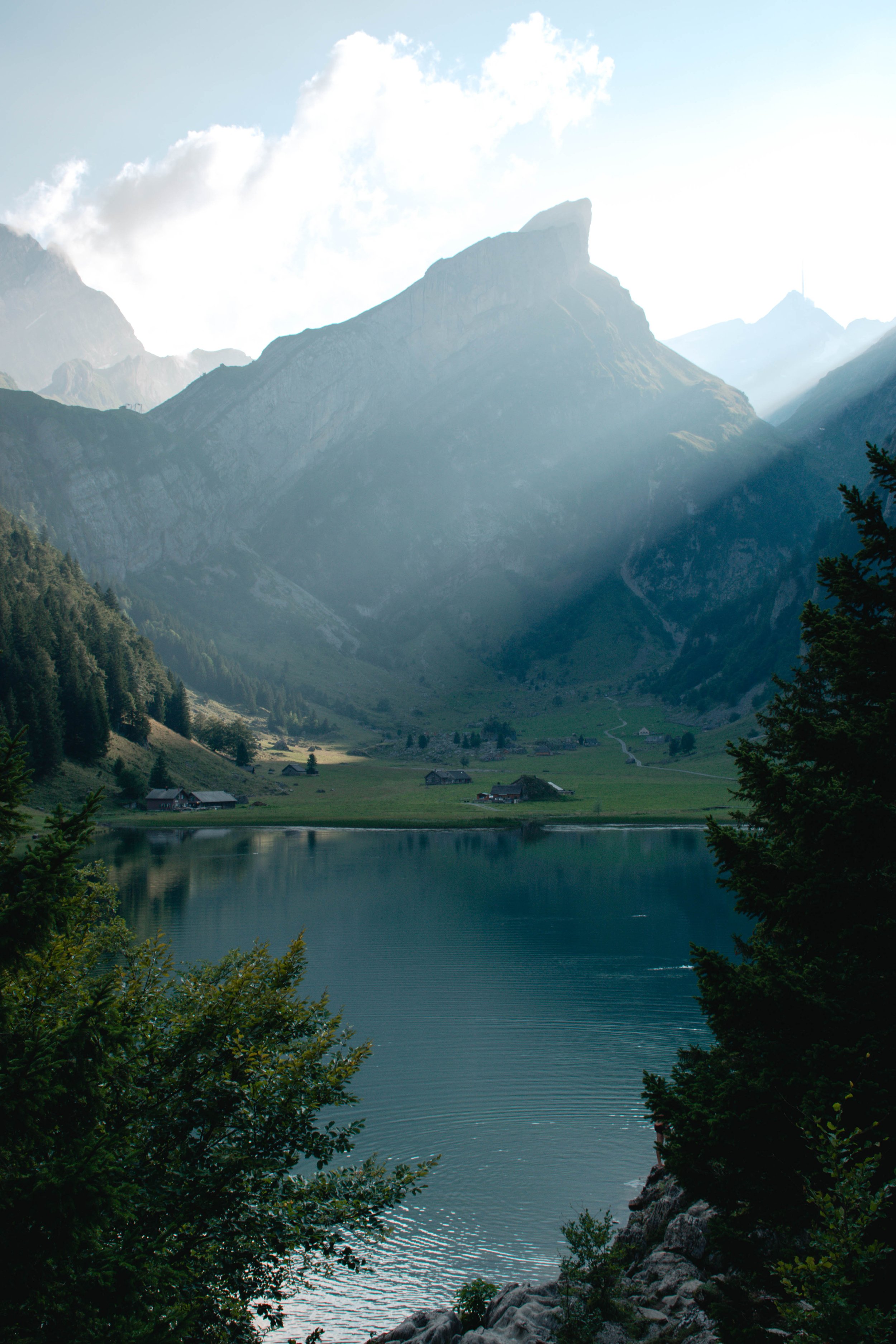
You’ll enjoy Swiss landscapes like this one…
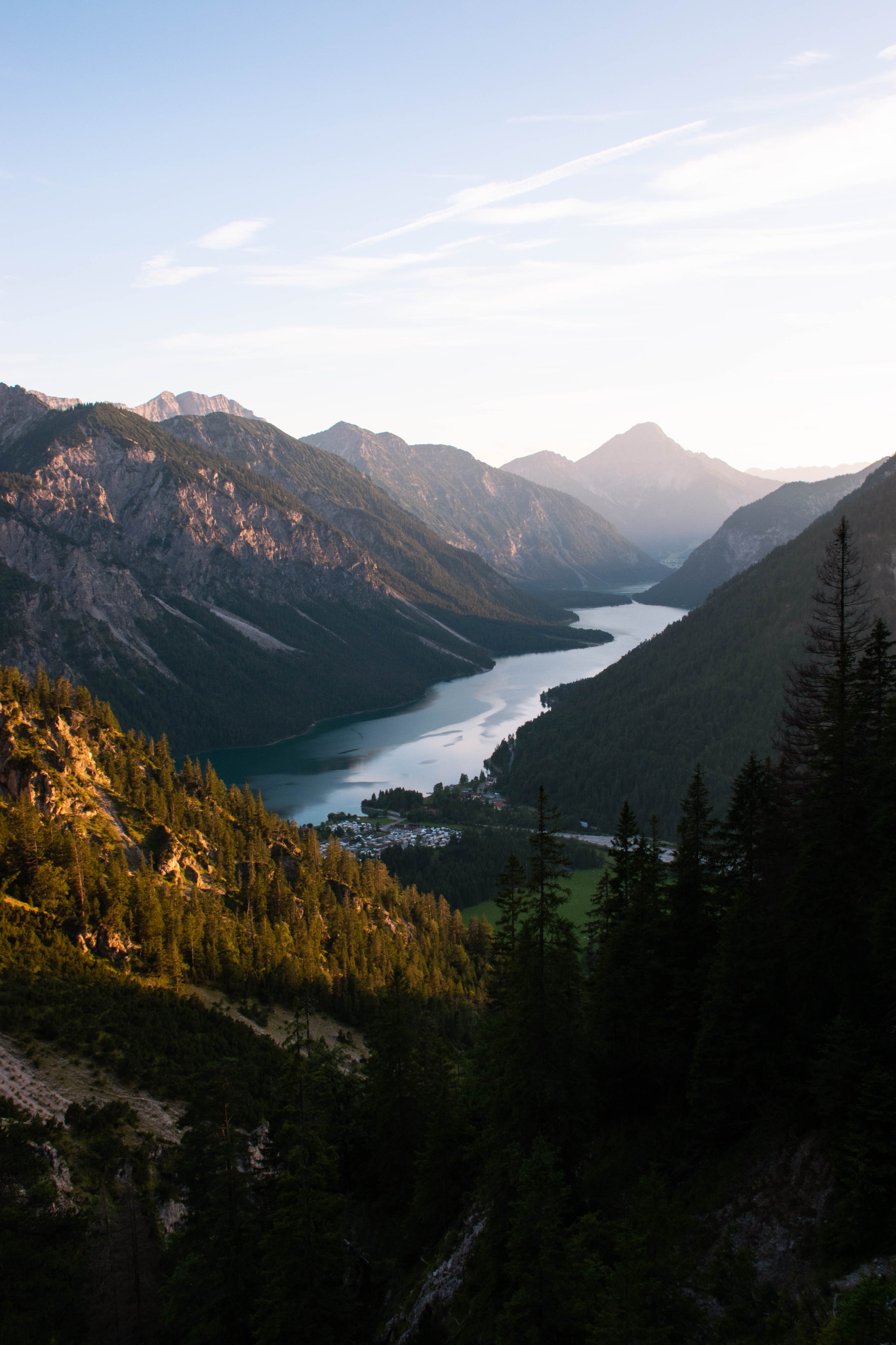
…and gorgeous vistas in Austria such as this
Table of Contents
Day 1: Stuibenfälle & Plansee, Austria
🚗 Distance you’ll drive: 30 km from Plansee to Ehrwald, additional driving around Plansee if needed
🚶♀️ Distance you’ll hike: anywhere from 4 to 25 km depending on your preferred activities
🌙 Stay overnight in: Ehrwald
The road trip begins by exploring one of Austria’s most popular regions. Tyrol, nicknamed the heart of the Alps, is a paradise for adventurers all year round.
Stuibenfälle loop
The day starts with a short and relatively easy four-kilometre loop around Stuiben Falls (Stuibenfälle). It’s a picturesque route leading through a forest, along the water, and around a couple of waterfalls.
Leave your car at Parkplatz Stuibenfälle and follow the signs to the lookout point. Head down from here and walk the trail clockwise. Including stops, the whole loop should take around two hours.

The most photographed spot at Stuiben Falls

Searching for hidden gems along the trail
There is one incline through the forest that’s a bit steeper. For the rest, it’s an easy walk. The area is also popular for canyoning tours if that’s something you want to give a shot.
After you’ve completed the Stuibenfälle loop, it’s time to move on to Plansee, which is actually connected to the falls.
Plansee
Plansee is a true hidden gem. The lake covers an area so large that even at the height of the summer season, you can find spots along the water where you will not be disturbed by anyone. It’s about six kilometres long and one kilometre wide. At its deepest point, it reaches 78 metres.

The water is crystal clear

Plansee is perfect for water sports
You can walk around the entire lake, which should take about four to five hours (14 km). If you’re a bit short on time or simply want to save your energy, I’d recommend an out-and-back walk from Camping Seespitze across the bridge and along the western shore to Heiterwanger See.
You’ll find pretty lookout points as well as little hidden spots where you can lay down your picnic blanket and chill — or go for a quick dip. Beware though. Even in the heat of the summer’s sun, the water feels freezing cold.

A strip of water connecting Plansee with Heiterwanger See
Sunset hike to Schönjochl
Had enough relaxation and fancy a little sunset hike? From Camping Sennalpe on the eastern edge of the lake head towards MusterAlpe Plansee hut and on to Schönjochl.
There’s an eight-kilometre-long loop hike you can do which is described here. However, there are a few things you need to keep in mind:
The loop takes longer than it seems. If you start too late, you may not make it before it gets dark.
The trail is not very well marked, so it’s good to have a paper map or download a tourist map on your phone.
The trail is narrow and at times exposed. Not recommended it in the dark.
We visited in August and started hiking around 6 PM. People warned us that we would not make it — and they were right. We didn’t even make it to Schönjochl, let alone finish the loop.
It started getting dark when we were maybe one-third in. So we turned back and hiked down the same way we came from.

You don’t even need to reach Schönjochl to get some amazing views of Plansee
Luckily, this was already pretty high up so we still got some great views! Hiking up for a bit and then coming back down is therefore a great alternative to the loop hike.
TIP: Plansee is located just a few kilometres from the German border. If you have extra time, add a day trip to the nearby area around Zugspitze — Germany’s highest peak. It’s home to one of the most beautiful lakes in the Bavarian Alps!
Day 2: Drachensee & Seebensee Circuit Hike, Austria
🚗 Distance you’ll drive: 80 km from Ehrwald to Innsbruck
🚶♀️ Distance you’ll hike: 15 km
🌙 Stay overnight in: Innsbruck
Day two starts at the bottom station of the Ehrwalder Alm cable car. You’ll be setting off on a 15-kilometre-long circuit hike through the Mieming Range to visit two of the most popular lakes — Drachensee and Seebensee.
Ehrwald to Hinteres Tajatörl
Take the cable car up from the parking lot in Ehrwald and hit the trail in the direction of Coburger Hütte. The first 45 minutes from the Ehrwalder Almbahn mountain station to Ganghofersteig Intersection are easy breezy compared to what awaits you after that.
Follow the signs to Brendlkar and Tajatörl. At some point, there’s an intersection where you have the choice between that or Seeben Alm/Coburger Hütte. Going directly towards Seeben Alm would make you miss the best part of the hike!

This is still the easy part of the hike

The strenuous ascent is redeemed with views like this one
The next two hours on the Ganghofersteig trail will, quite literally, be your purgatory. You’ll be walking up a narrow forest trail, scrambling up screes, walking up through alpine pastures, and scrambling up on a rocky terrain some more before you emerge victorious on the top of Hinteres Tajatörl.
In the words of Ron Weasley, “You’re gonna suffer, but you’re gonna be happy about it.”
Drachensee & Seebensee
Soon after passing Hinteres Tajatörl, you can already see the first of the two iconic lakes — Drachensee — below.
After hours on the trail, it seems that you’re finally getting somewhere. But don’t be fooled. You’ll be hiking for at least another hour, hour and a half before you can rest your feet and enjoy Tyrolean cuisine with views at Coburger Hütte perched above the lake.

High above Drachensee — still quite a hike to reach the lake
Take all the rest you need before you move on. The steep and rocky descent towards the next lake — Seebensee — takes about half an hour.
With its stunning reflections, Seebensee is a paradise for photographers, especially at sunset. If you can, sit down on one of the benches and take in the views.
The walk back to the cable car takes something over an hour. This is generally the busiest part of the trail, as many people walk directly from the cable car station to Seebensee, Drachensee and back.

Seebensee from above…

…and from below
However, if you’re here in the evening, there’s no need to worry about crowds. You will pretty much have the place all to yourself.
What you do need to worry about, though, is how you’re gonna get back down to the parking lot. In high season, the cable car stops running around 5 PM.
There’s a road leading down the mountain which is typically used by cars supplying the various mountain huts. It’s straightforward and its surface is very easy to walk in the dark with a headlight.
However, its steepness will put some strain on your knees, and after a whole afternoon of hiking, the descent just feels endless — something to keep in mind, should you decide to watch the sunset at Seebensee.

Evening reflections at Seebensee

Sunset lights the rocks on fire
Day 3: Exploring Muttereralm & swimming near Innsbruck, Austria
🚗 Distance you’ll drive: 35 km (11 km from Innsbruck to Nockspitzbahn, 16 km from Nockspitzbahn to Lanser See, 8 km from Lansersee to Innsbruck)
🚶♀️ Distance you’ll hike: a few hundred metres
🌙 Stay overnight in: Innsbruck
After two days packed with activities, it’s time to relax. On day three, there’ll be no strenuous hikes and no long walks either.
Muttereralm Park & Speichersee
A quick 20-minute drive from the Innsbruck city centre is the Muttereralm Park — a paradise for families, kids, and all-around adventurers. It’s the perfect place to see and do nice things without having to cover a lot of distance.
To get up to the park, you can either take the Muttereralm cable car or the Nockspitz cable car. We went with the latter and parked our car at Nockspitzbahn Parkplatz.
Once you’re up, head to Speichersee (also known as Panoramasee), a small artificial lake with impeccable reflections of the surrounding landscape. Walk around, enjoy the views, and allow yourself to slow down.
Unfortunately, it’s not allowed to swim in the lake. That’s why we’ll head somewhere else for a little refreshed later on.

Mirror-like reflections

Stunning vistas at Speichersee
But first, you need to get back down to the car. One option is to simply take the cable car. The other option — a slightly more adventurous one — is mountain carting down a closed-off five-kilometre long mountain cart track!
It’s a pretty popular activity up here so you might have to wait in line for your turn. Renting a mountain cart is possible up to half an hour before the cable car stops running. You’ll need to show your ID.
The price is around €15 per person. You’re not allowed to go mountain carting with open shoes so make sure you’re wearing sneakers.
Mountain carting down from Muttereralm Park to Nockspitzbahn parking lot
Swimming in Lanser See near Innsbruck
Once you get down, return the cart, hop in the car, and head to Lanser See — a popular recreational lake near Innsbruck. This is where you can spend the rest of the day swimming, reading, and relaxing. The entry costs around €5 after 3 PM.
Day 4: Seealpsee & Lake Constance, Switzerland
🚗 Distance you’ll drive: 190 km from Innsbruck to Seealpsee, 47 km from Seealpsee to Romanshorn
🚶♀️ Kilometres you’ll hike: between 5,6 km and 7,3 km
🌙 Stay overnight in: St. Gallen, Romanshorn, or Konstanz
On day four, it’s time to move from Austria to Switzerland. You’ll be venturing into the Apenzell area and witnessing one of the most popular Swiss lakes.
Seealpsee
Seealpsee is probably one of the most beautiful — and most accessible — alpine lakes in Switzerland. The Alpstein peaks in the backdrop have such a distinct shape that if you’ve seen them once, you will always recognize them.
The trail to Seealpsee is very easy, making it suitable for less experienced hikers as well as families with children.
Leave your car at the Wasserauen parking lot. From here it’s roughly a three-kilometre walk. The road inclines more and more as you’re getting closer to the lake but it’s nothing crazy.
The final part just before the lake feels like you’ve stepped inside a fairytale. Tiny huts and surrounding pastures make you feel small as if you’re walking across a Swiss version of Hobbiton.
The winding gravel road leading towards the restaurant makes you wonder what the views are going to be once you finally cross that last little hill.

Just a couple hundred metres to the lake

Feels like Swiss Hobbiton
Lounge at the water, enjoy an afternoon picnic or sit down at the local restaurant. There are many spots from which you can enjoy the views.
A loop around the lake is less than two kilometres on a flat gravel road. Halfway through you can taste some fresh milk at a local hut. Great refreshment before completing the loop and heading back down to the parking lot.
The road from Wasserauen is the easiest way to get to Seealpsee but there are other, more challenging, routes for the keen hiker.

Hop on a boat for some unique views

An ideal picnic spot
Lake Constance
If you have time on your way from Seealpsee, make sure you check out St. Gallen. This Swiss town is known for its Abbey Library, dubbed one of the most beautiful libraries in the world.
Lake Constance (or Bodensee in German) is the third largest freshwater lake in Central and Western Europe. Its length is 63 kilometres and the lake is surrounded by three countries: Switzerland, Austria, and Germany. It’s a popular area for summer recreation.
There are a number of towns along the lakeshore, providing a multitude of options for accommodation. The most notable — and largest — is probably Konstanz, which is actually in Germany. A great opportunity to squeeze another country into this trip. 😉
We chose to stay overnight in Romanshorn, simply because there were very few affordable accommodation options left when we were planning the trip (about a week before departure).
It’s not your tourist hot spot which translates into fewer options in terms of restaurants and cafés. However, there are definitely some upsides to it. It’s not very busy and there’s a possibility to go for a serene morning swim at Badeplatz Güttingen — a 10-minute drive from Romanshorn.

Light play in the Swiss Alps

Morning swim at Lake Constance
Day 5: Rhine Falls, Switzerland
🚗 Distance you’ll drive: 80 km from Romanshorn to Rhine Falls (Neuhausen am Rheinfall)
For the grand finale of this trip, you’ll be heading to Rhine Falls — the largest waterfall in Europe.
It reaches a width of 150 metres and the average water flow is 600 m3/s in the summer. Still not impressed? The waterfall is over 15.000 years old!
Taking all of this into consideration, it is an extremely popular tourist destination. Parking lots designated for visitors of the Rhine Falls fill up pretty fast, so it’s best to find a suitable spot on the street somewhere in the vicinity. Parking on the streets is paid.
Unless you’re here in the early morning, expect hordes of people queuing up at about every lookout point. Snap some photos and walk across the bridge to see the waterfall from the other side.
You can visit the local castle for a fee. There are also short boat trips which give you the possibility to reach the rock in the middle of the waterfall.
Last but not least, Rhine Falls is located just a five-minute drive from the border of Germany, where you can easily continue your Europe adventures!

Explore the waterfall from all sides

You can visit the rock in the middle of the waterfall
Austria and Switzerland are some of the best countries in Europe for road-tripping, hiking, and other outdoorsy adventures. With magnificent peaks of the Alps, stunning lakes, and 10/10 scenery pretty much everywhere you look, you really cannot go wrong by choosing them for your next summer getaway.


Have you already done a road trip through Austria and Switzerland? What would you add to the itinerary? Leave a comment below!